|
|
Google Earth Images with GPS Tracks
from Noumea to Guadalcanal and
Tour of Guadalcanal (turquoise) |
After
a 3 night and 2 day sail from Noumea, New Caledonia, the ship
arrived at Honiara, Guadalcanal,
Solomon Islands.
Guadalcanal is the island where
Allied forces arrested Japanese
expansion into the southwest Pacific
in late 1942. Costly land and
naval battles here resulted in heavy
losses for both sides, but in the
end the Japanese retreated. |
 |
|
Docked at Honiara, Guadalcanal, Solomon Islands |
|
The “locals”, decked out in war paint, performed dockside. They used pan flutes of various sizes.
Click on the photo to view
a Windows Media Player (.wmv)
video of the performance
(2.6 MB file).
Click
here to view an Apple
Quicktime (.mov) version of
the video (4.1 MB file). |
|
|
 |
|

|
|
Honiara |
|
Honiara is the capitol city of the
Solomon Islands. It was
established after WW2 and replaced
Tulagi as capitol.
I took many
digipics from the ship while the weather
was clear.
This view
is looking south from the ship.
The main street of Honiara is in the
foreground. The conical shaped
building serves as the capitol
building of
the Solomon Islands. |
|
|
|
Guadalcanal Coastline and Iron
Bottom Sound |
Looking northwest from
Honiara Harbor across the
Solomon Sea. Cape Esperance
is at the far right.
Savo Island is just outside
this photo to the right.
The Solomon Sea immediately
north of Guadalcanal is
known as "Iron Bottom Sound"
because of all the ships
sunk here. Important
naval battles fought in
these waters include the
Battle of Savo Island, the
Battle of Cape Esperance,
the First and Second Naval
Battles of Guadalcanal, and
the Battle of Tassafaronga.
Click
here for a map and
information on these
battles. |
|
 |
|

|
|
Inter Island Ships at Honiara |
|
There were
several small
ships in the harbor which transport people and
goods between the islands. Very
colorful.
|
|
|
|
Guadalcanal American Memorial |
The WW2
History Tour began at 12:30
PM. Vehicle was a 10
passenger Toyota van. Guide
and driver both spoke fair
English.
First stop was the
Guadalcanal American Memorial
located on a
hill (see map in 1st
frame). It has granite walls
inscribed with accounts of
the battles. The walls
are oriented to point at
the locations of the battles. |
|
|
 |
|

|
|
Memorial Wall |
| This
wall described various engagements
including the 1st Naval Battle of
Guadalcanal. The wall is
pointed at Iron Bottom Sound between
Tulagi and Savo Island.
|
|
|
|
Memorial Wall Regarding the 2nd
Naval Battle of Guadalcanal |
This wall described the 2nd
Naval Battle of Guadalcanal,
which involved the US
battleships Washington and
South Dakota. |
|
|
 |
|

|
|
Savo
Island from the Memorial |
|
A 3x
teleview which includes the areas of
Iron Bottom Sound on which most of
the naval battles occurred.
Note the tropical vegetation and
houses in the residential area in
the foreground.
|
|
|
Guadalcanal Residents |
En route
to and from the Memorial we drove
thru residential areas. The
"locals" were very friendly
and most waved
enthusiastically. They are
Melanesians with black or
dark brown skin and wooly
hair. Many people about,
lots of kids. Some of the
children had fairly blonde
hair. Houses were generally
on stilts. Vegetarian was
lush tropical. |
|
|
 |
|

|
|
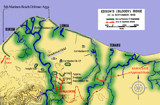
Bloody (Edson's) Ridge |
|
Looking
north towards Henderson Field.
This is where outnumbered US Marines
repulsed a night time charge by 3000
Japanese trying to take Henderson
Field, about a mile distant.
The charge was essentially from the
lower left. Click the photo to
view a map.
Click
here for a USMC history of the
Guadalcanal campaign. Scroll
to page 25 for Bloody Ridge.
For an animated account of battle, click
here.
|
|
|
Bloody (Edson's) Ridge |
Looking south (inland). This
is the direction from which
the Japanese attack came.
There is a small concrete
monument on the ridge, but
the bronze plaque was
missing. Local people
came to the ridge to try and
sell war relics, such as
mess ware, badges, shell
casings, etc.
The road to the ridge was
rough dirt. It crossed
private property, and the
owners expected a toll to be
paid.
|
|
 |
|

|
|
Henderson Field |
| This
airfield was under construction by
the Japanese when it was taken by US
Marines in August, 1942. US
Seabees completed the airfield and
it was used by Allied planes in
extensive combat and transport
operations to great effect. Possession of the
airfield was the goal of both sides
in the Guadalcanal campaign.
The
remains of the US WW2 control tower
are visible in the right center of
the photo.
|
|
|
Henderson Field |
Today Henderson Field is
also known as Honiara
International Airport.
We were visiting the
Terminal Building when an
intense thunderstorm moved
over the area. After
discussion with the guide we
decided to skip the visit to
a market place and return to
the ship. We did drive by
the market, which looked
very interesting. Folks
there were huddled under the
palm frond shelters. We saw
flooded soccer fields with
play continuing. Several of
the roads were flooded and
we had to find detours. Back
at the ship the vans lined
up and waited until we could
step directly out of the van
onto the gangway, which was
very considerate of the tour
guides. |
|
 |
|

|
|
Iron Bottom Sound |
| Cape
Esperance at the left, Savo Island
near the center.
|
|
|
|
Departing Honiara, Guadalcanal |
The ship departed at 5:00 PM in
the rain and headed for Savo
Island. |
|
|
 |
|

|
|
Savo Island |
|
A mile off
shore the ship slowed to 4 kts and
cruised by Savo Island. A
memorial ceremony was held, inside
because of the weather. A
bugler played taps and wreathes and
flowers were tossed into the ocean from
the Promenade. The ship then did
traditional S-turns at 5 kts and
sounded its horn to honor the
fallen.
We then
began our sail to Rabaul up the
“Slot” between islands on the route
the "Tokyo Express" used to resupply
Guadalcanal.
All in all, it was a very good
visit.
|
|
|
|